Our mission: Get early warning systems into places they are needed for the protection of people and wildlife
LeopardEye UPDATE 17 October 2026 – A message from Jack Kinross
Village and Wildlife Protection Advantage (VWP) – Currently, born out of necessity and part of the LeopardEye evolution, we have formed a module called VWP. Through various technology applications and working closely with communities, we currently have a pilot in Bardiya, west Nepal. Different systems are in development using cellular, satellite, drone and telemetry technologies to bring safety to people and wildlife in an area where there are serious coexistence challenges. We’ll update in November 2026.
As well as this. on 26 August, a terrible tragedy struck Nepal, currently my main base. Thousands of people have been killed in an event which has rocked the nation, a deadly flood occurring after a massive landslide in the Langtang Himalaya on the Nepal–Tibet border. Due to the scale and seriousness of this event, we are stepping up efforts in the development and deployment of LeopardEye so that early warning and monitoring systems can be in place to help avoid incidents of such massive loss of life as has just occurred. Landscape monitoring to mitigate human-wildlife conflict and wildlife crime has long been the focal point of LeopardEye so it is logical that we increase resources so as to combine human safety improvements in a holistic approach in fragile habitats, especially the Himalaya. Please go through this site to further understand our work and there’s more information especially with regard to these latest developments at my Substack– The Leopard. I’ll update at all platforms as appropriate. Please read below to understand more about LeopardEye and if you are new to the site, please read Why We Must Protect the Leopard as a starting point on the species we use as the flagship for our work. As much as anything, our mandate is about getting conservation technology into the right places, we’ll have updates on our flagship missions soon.
We’re now in a position where devices used in various ways start at $100USD and there are cloud/data costs to cover for devices. Every contribution, big and small, makes a difference and as we expand, so do the challenges to cover costs. If you can help in any way, please go HERE, it makes a difference and is very much appreciated.
LeopardEye
Prevention Through Intelligent Landscape Monitoring
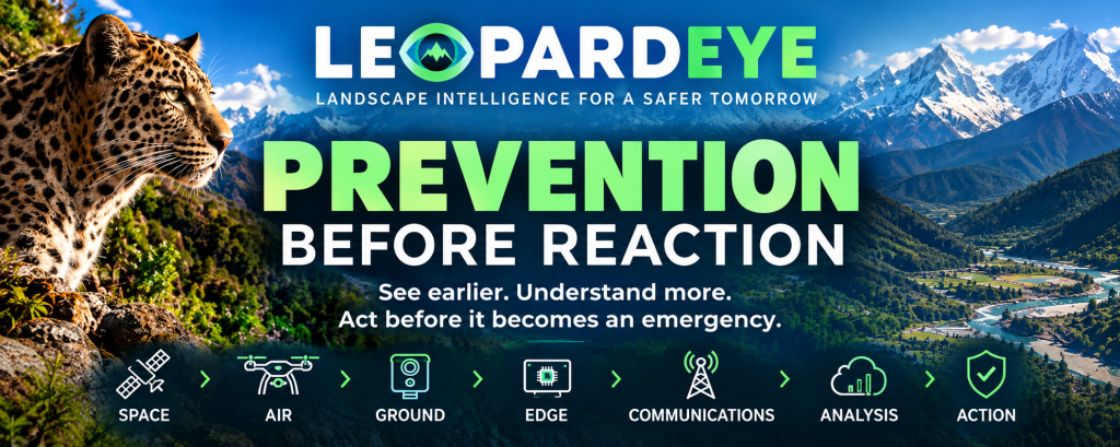
See earlier. Understand more. Act before it becomes an emergency.
LeopardEye is evolving from a wildlife monitoring and early-warning system into a resilient, multi-layer landscape intelligence platform.
Its original purpose was to use technology to protect wildlife, reduce human–wildlife conflict and support people working in difficult conservation environments.
That remains at its core.
But the same principle applies far beyond wildlife:
If we can detect change early enough, we may be able to prevent a crisis rather than simply respond to it.
This is the direction of LeopardEye.
Prevention, Not Reaction
Too often, environmental and wildlife management is reactive.
Poaching occurs — we discover the evidence afterwards (please go to #AntiSnare where LeopardEye is a key tool).
A flood occurs — we respond.
A landslide happens — we investigate.
A glacier or unstable slope fails — we assess the damage.
A leopard enters a settlement — we begin dealing with the conflict.
A communications network fails — we discover that the monitoring system depended upon it.
LeopardEye is being developed around a different principle:
Monitor continuously. Detect change early. Assess developing risk. Communicate information while there is still time to act.
Technology cannot prevent every natural disaster, wildlife encounter or environmental change.
But better information, available earlier, can create something extremely valuable:
time.
And in many emergencies, time is the difference between prevention and response.
From Early Warning to Early Action
The catastrophic Himalayan disaster of August 2026 demonstrated the importance of this principle.
Satellite observation subsequently helped reveal the scale and consequences of the event. More importantly, questions arose about whether changes occurring in the landscape before the collapse might have provided indicators of increasing instability.
That raises the fundamental question now driving LeopardEye:
What if satellite observation, ground monitoring and intelligent analysis could be combined to identify developing risks before they become disasters?
That is the challenge LeopardEye is being designed to address.
The objective is not simply to produce more warnings.
It is to provide better evidence, earlier, so that scientists, conservation professionals, emergency services, communities and government authorities can make better decisions.
A Landscape Intelligence Platform
LeopardEye is no longer simply:
Camera → 4G → Server
It is developing toward a much broader architecture:
SPACE → AIR → GROUND → EDGE → COMMUNICATIONS → ANALYSIS → ACTION
Different layers provide different perspectives.
Space
Satellite Earth observation can provide wide-area monitoring of places that are too large, remote or inaccessible for continuous ground observation.
Potential applications include:
- glaciers and glacial lakes
- rivers and water systems
- snow and ice
- unstable slopes
- landslides
- flood and debris-flow conditions
- habitat change
- forest disturbance
- infrastructure and access routes
- changes in remote terrain
Air
Drones and other aerial systems can provide targeted observation between satellite-scale monitoring and ground-level systems.
Ground
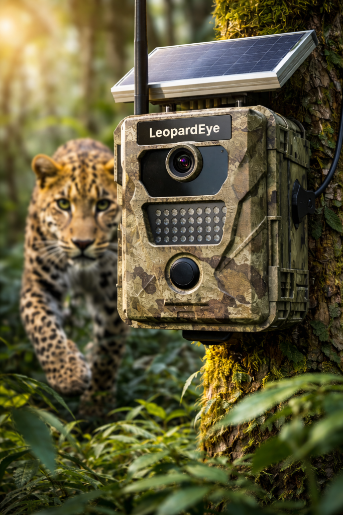
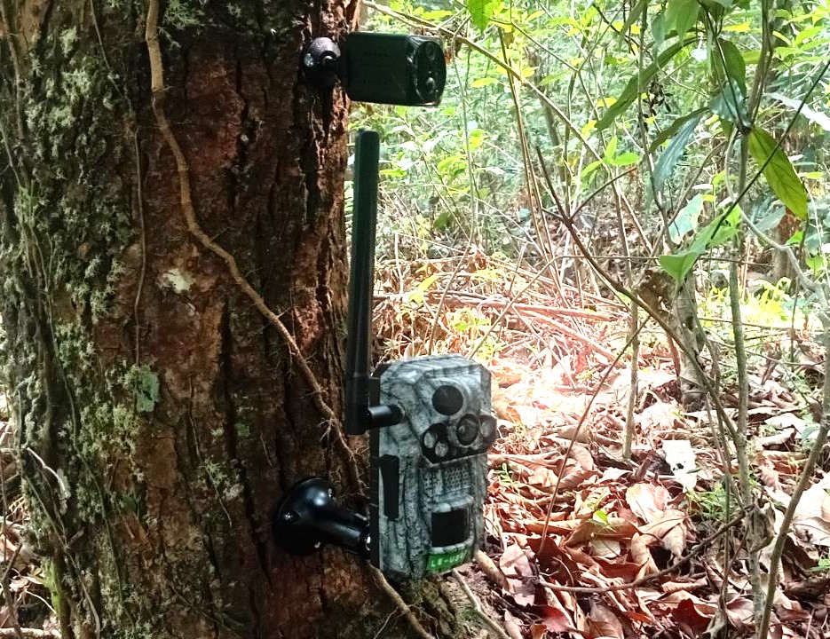
LeopardEye stations can provide persistent, localised observation through cameras and environmental sensors.
Depending upon the deployment, these can monitor:
- wildlife
- human activity
- water levels
- river conditions
- weather and environmental conditions
- movement
- infrastructure
- other indicators of change
Edge Intelligence
Where communications are limited, information can increasingly be processed close to where it is collected.
The objective is not to transmit everything.
It is to identify potentially significant events and communicate the information that matters.
Resilient Communications
4G remains valuable where it is available.
But remote landscapes cannot always depend upon terrestrial networks.
LeopardEye is therefore being developed to incorporate satellite communications where required, with local storage providing another layer of resilience.
4G where available. Satellite where necessary. Local storage when neither is available.
A communications failure should not automatically become a monitoring failure.
The Critical Difference: Change
One of the most important principles behind LeopardEye is change detection.
Traditional monitoring often asks:
What is there?
LeopardEye increasingly needs to ask:
What has changed?
A single image of a mountain, river or forest provides information.
A sequence of observations can reveal movement, expansion, retreat, disturbance or other changes that may be significant.
The same principle applies to wildlife.
A LeopardEye station can establish a baseline of normal conditions and identify significant departures from that baseline.
The developing intelligence cycle is therefore:
BASELINE → OBSERVATION → CHANGE → CORROBORATION → ASSESSMENT → ALERT → ACTION
Not every change represents danger.
Not every alert requires intervention.
Artificial intelligence should not create false certainty.
Instead, LeopardEye is intended to provide increasingly sophisticated evidence and indicators that allow qualified people to determine what requires action.
Monitor the Source — Not Just the Consequence
Prevention also requires looking beyond the place where the consequences eventually appear.
An environmental emergency may begin high in the mountains while its effects occur many kilometres downstream.
A useful monitoring architecture therefore considers:
SOURCE → PATHWAY → RECEIVING ENVIRONMENT
For example:
Glacier / slope / lake
↓
Tributary / river
↓
Communities / infrastructure
The same principle applies to wildlife protection:
Habitat → Movement corridor → Human interface → Community
And to wildlife crime:
Protected area → Access route → Transport corridor → Border / marketplace
Understanding the entire system creates a much greater opportunity for prevention than monitoring only the final point of impact.
One Platform, Many Applications
Although LeopardEye began with wildlife protection, its underlying architecture is deliberately modular.
The same platform can potentially support:
Environmental and Hazard Monitoring
- glacial lakes
- glaciers and high-mountain environments
- rivers and water levels
- flood risk
- landslides
- unstable terrain
- remote infrastructure
Wildlife Conservation
- wildlife movement
- habitat monitoring
- human–wildlife conflict
- anti-poaching
- patrol support
- evidence collection
Remote Landscape Monitoring
- roads and bridges
- hydropower infrastructure
- isolated settlements
- access routes
- environmental disturbance
The objective is not to turn every LeopardEye deployment into a disaster-monitoring system.
It is to create a flexible technology platform capable of being configured for the risks and monitoring requirements of each landscape.
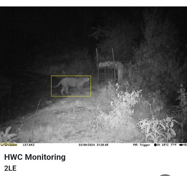
Prevention Across Wildlife and People
This broader direction does not represent a departure from LeopardEye’s original mission.
Wildlife protection remains fundamental.
Indeed, the connection is stronger than it may first appear.
A system capable of identifying developing environmental change can also identify disturbance in wildlife habitat.
A communications system capable of operating beyond reliable 4G can support conservation work in remote areas.
An early-warning system capable of detecting approaching wildlife can help prevent human–wildlife conflict.
And reducing conflict can reduce the conditions that contribute to retaliatory killing, snaring and ultimately wildlife trafficking.
This is why LeopardEye is increasingly viewed not simply as a wildlife camera system, but as a prevention and intelligence capability.
Why This Matters in the Himalaya
Nepal illustrates the challenge particularly clearly.
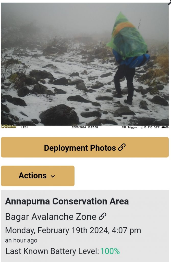
Large areas of the country are mountainous, remote and difficult to access. Communications infrastructure can be uneven. Weather and terrain can change rapidly. Roads and other infrastructure can be damaged or destroyed.
At the same time, these landscapes contain globally important wildlife habitats, fragile mountain ecosystems, major river systems, glacial environments and communities living directly within them.
Conventional monitoring alone cannot provide continuous visibility across such enormous and difficult terrain.
LeopardEye’s ambition is to combine multiple forms of observation so that important changes do not have to wait until somebody physically reaches the location to be discovered.
Technology Does Not Replace People
LeopardEye is not intended to replace scientists, conservation professionals, emergency responders or government authorities.
Nor can technology guarantee the prevention of every disaster.
Its role is different.
Observe more. Detect earlier. Understand better. Communicate reliably.
Then allow the people responsible for decisions to act with better information.
Artificial intelligence can help identify patterns and changes across enormous quantities of information.
Satellites can provide the wide view.
Ground systems can provide the close view.
Sensors can provide measurements.
Communications can keep information moving when conventional infrastructure is unavailable.
But ultimately:
People make the decisions.
LeopardEye exists to give them a better chance to make those decisions before it is too late.
The LeopardEye Vision
The long-term vision is a continuously monitored landscape in which multiple sources of information can be brought together:
SATELLITE EARTH OBSERVATION
↓
AERIAL OBSERVATION
↓
LEOPARDEYE GROUND STATIONS
↓
ENVIRONMENTAL SENSORS
↓
EDGE INTELLIGENCE
↓
4G / SATELLITE COMMUNICATIONS
↓
SECURE DATA PLATFORM
↓
AI-ASSISTED ANALYSIS & CHANGE DETECTION
↓
EARLY WARNING / DECISION SUPPORT
↓
ACTION
The purpose is not more data.
It is earlier understanding.
And earlier understanding creates the possibility of prevention.
From Reaction to Prevention
LeopardEye is developing toward a simple but important change in philosophy.
Not:
Something happened. What do we do now?
But:
Something is changing. What does it mean — and what can we do before it becomes a crisis?
That principle applies equally to wildlife, communities and landscapes.
It applies to a leopard approaching a settlement.
A river rising upstream.
A glacier changing.
A slope becoming unstable.
A remote road becoming inaccessible.
A protected area experiencing human intrusion.
A communications network going down.
In every case, the objective is the same:
See the change. Understand the risk. Communicate the information. Act early.
Prevention is the goal.
Looking Ahead
LeopardEye is currently being developed as a modular platform incorporating ground-based monitoring, environmental sensors, satellite communications, satellite Earth observation, edge intelligence and increasingly sophisticated analytical capabilities.
Its technology will continue to evolve through field experience and collaboration with technology providers, conservation organisations, scientists and government authorities.
The ultimate objective is straightforward:
To provide the intelligence needed to protect wildlife, people and landscapes before preventable problems become irreversible ones.
LeopardEye is becoming more than a wildlife monitoring system.
It is becoming a platform for seeing, understanding and preventing.
From reaction to prevention.
From isolated observations to landscape intelligence.
From responding to events to identifying change before the event.
See earlier. Act sooner. Prevent where possible.
Everything we do at Mission Leopard has the ultimate goal of evoking the Spirit of the Wild.
